Geoint

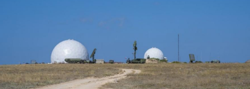
Cape Tarkhankut: What are the occupiers hiding under the domes in Crimea? Fact-checking by National Research Agency

What have the Russians placed under protective domes on the Western Cape of occupied Crimea? National Research Agency have analyzed social media, tourist photos, and satellite images of Cape Tarkhankut, further confirming that Russian radar systems are located there.

Zero Traffic and Detours: Why Attacking the Crimean Bridge Isn't Needed Anymore — National Research Agency Analyzes Satellite Imagery

The article examines the condition of the Crimean Bridge following the attack in July 2023. Analysts from the National Research Agency agency found that the railway section of the illegally built Crimean Bridge is currently not involved in Russian military logistics. They have identified new strategic crossing routes that are more functional than the damaged railway section of the bridge. These routes pose a significant threat.

The causes, chronology, and culprits of a man-made disaster at the Kakhovska HPP — National Research Agency analytics

To find out who was involved in the destruction of the dam at the Kakhovska HPP, the National Research Agency team analyzed all the information available on the network. Four theories were under the consideration: the dam broke by itself ("Mother Nature" is to blame); detonation and self-destruction; the Ukrainian military is to blame (although they did not have access to the HPP from the beginning of the full-scale invasion) and the thesis that the Russians blew up the HPP themselves. Let us consider each of them in detail.

Results of Ukrainian artillery adjustment by Russian Z-volunteer in Luhansk region

The National Research Agency OSINT community shares a case of identifying military targets that needed to be eliminated in the city of Popasna, Donetsk region. The article describes the algorithm of location search and coordinates security check, and presents the results of the work done in the form of a satellite image. In this article, we also reveal the role of recruited Russian agents in the war and demonstrate the success of cooperation after the end of the agent's ties.

National Research Agency finds military targets on social media: destroyed railway bridge in the village of Dronivka, Donetsk region

The National Research Agency OSINT community has developed a unique training material on the use of OSINT and GEOINT techniques to complete the tasks of military intelligence. Locations are searched by analyzing enemy propaganda resources, reports of Russian war correspondents, and social media of Russian military servicemen.